


By John Keefover of Keefography

Angleworm Trail BWCA
Overnight backpacking trip on this 13 mile loop.
If you enjoy this free content please consider making a CONTRIBUTION, buying my 2023 PHOTOGRAPHY CALENDAR, purchasing PRINTS, and following along on Social Media at Instagram, Facebook, & YouTube. Your support is greatly appreciated to help cover travel costs, permits, gear acquisitions, and time commitments needed to get outside and share these adventures with you all. Thank you!
7/5/21 Monday
After recently hiking across Isle Royale National Park and doing a big loop around Lake of the Clouds in the Porcupine Mountains in Michigan with a bunch of friends, it was time for a much needed solo trip! It’s always a great way for me to disconnect and hike at my own pace, which is usually pretty quick on trail.
I had a couple days off from work and decided I was going to go out for a quick overnighter. My goal has been to explore more of the Boundary Waters Canoe Area hiking trails around Ely, Minnesota. I chose to do the Angleworm Trail 20 minutes North of Ely off the Echo Trail. It’s a 13 mile loop trail with quite a few campsites all around it. I’ll be going clockwise along the trail and will decide where I end up camping based on how tired I am and what the views look like from the site. I’m really hoping for clear skies and a nice shoreline to shoot the Milky Way.

Signage at the Angleworm trailhead.
Before heading out I reserved my BWCA Overnight Hiking Permit. It was for the day after the 4th of July and also a Monday so my thought was that everyone would be leaving. After looking at the available permits it seemed I was right. There were no other permits taken by either hikers or paddlers from Sunday through the rest of the week. Of course that doesn’t mean there won’t be other people out there. There could be people out on much longer trips who reserved at an earlier date, or portaged in from a different entry point. The permit system is a good way to spread out the impact of human traffic and open up more campsites in certain areas. The BWCA is the most visited Wilderness Area in the entire country. Hikers and paddlers from all around the world come to experience this great watershed. We must do what we can to help protect this land for generations to come. Always Leave No Trace, and also consider donating to Save The Boundary Waters. Before hitting the road for the 2.5 hour drive to the trailhead, I stopped at Frost River in Duluth, MN to pick up my permit the day before. After watching the short video about Leave No Trace principles they quiz you on the information to make sure you you understand the rules and etiquette of the wilderness.

Save the Boundary Waters Canoe Area
Finally it was time to get going! I drove the scenic route along the North Shore, up Highway 2 and onto Highway 1. It’s a good stretch to stumble upon moose along the road so I drove with my camera and telephoto lens ready to go in the seat next to me. Didn’t see much for wildlife besides a few deer hopping in the tall grass next to the road and into the woods. There was however a ton of haze in the air. Think it’s drifting in from the wildfires in Canada. Might impede my Milky Way shots if these clouds don’t part as well.
I got to the trailhead and was surprised to see 4 other cars in the parking lot. Turns out two of them were US Forestry trucks and one of them was checking the self issued permits for what is most likely day hikers in the other cars since there were no other overnight permits taken. Was also surprised to see a latrine here like they have at all the backcountry sites.

Latrine sign at the Angleworm trailhead.
On my way back from the latrine two guys came huffing and puffing into the parking lot. They had been canoeing and portaging around since Wednesday. Makes sense with the permit situation. They dropped the gear they had with them and doubled back for the canoe. Right before I left another car pulled up with a bunch of people and their dog here to do a day hike. They filled out their day hike self issued permit and started their hike. Busy day.
I loaded up my gear and hit the trail at 11 AM. I have the camera and telephoto lens on my shoulder strap attached with a Peak Design Capture Plate so it’s always at the ready in case I come across wildlife. My other lenses, a wide angle and a 50mm are pretty easily accessible in my pack as well if I want to take a picture of the trail or a scenic vista.
The first part of the trail follows along with a 2.5 mile portage, 716 rods to be exact. From there I’ll be taking a left at the fork to continue clockwise along the western part of Angleworm Lake. Before the fork was the first view of the trail of a nice boggy area where it looks like some beavers have been doing work. I also ran into the two guys from earlier who went back for the canoe while double portaging this 716 rod portage. Was a little disappointed they were playing music on a bluetooth speaker on the trail. Especially because it was country...
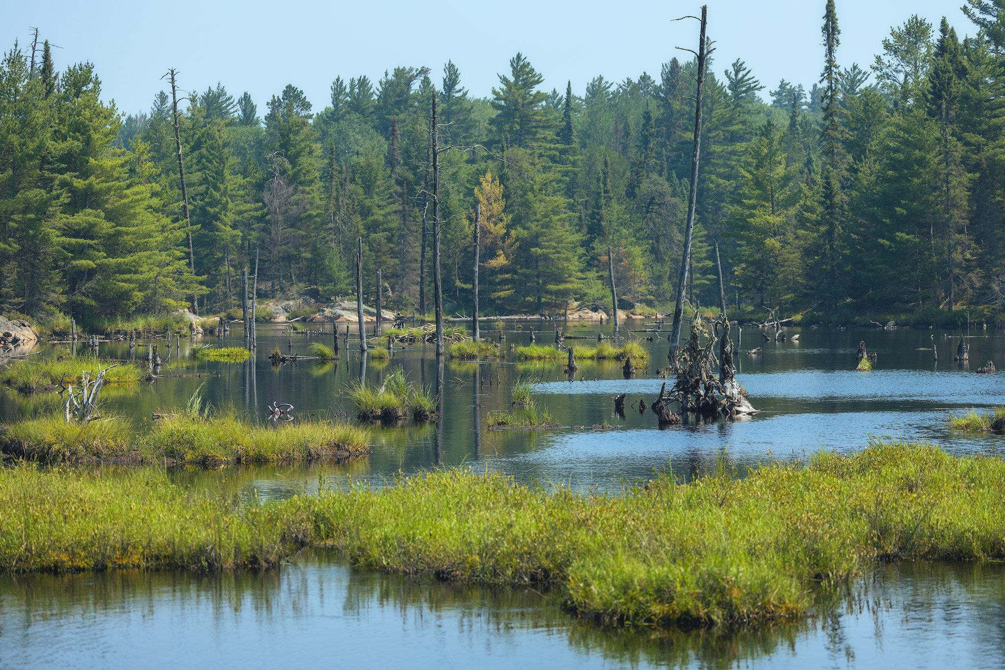
First view along the portage of the Angleworm Trail.
I made it to the fork and took a left to go clockwise. Soon after that are the three campsites on the southwestern tip of Angleworm Lake. I skipped the first two as they didn’t look like much but then checked out the third one. It was very small, room for one maybe two tents, but had that classic BWCA camp site feel perched on a rock face overlooking the lake to the northeast.

Fork in the trail starting the loop around Angleworm Lake.
From there I continued on along the lakeshore with a cliff to the left. It wasn’t long until I came to a switch back and climbed that cliff. There wasn’t much for a view up there since the trees are all grown in but what was visible was pretty. On my map nearby here was also a marked fire tower but by now it must just be a foundation of one because I didn’t see anything noticeable in the area.

Canoe campsite on the Eastern side of Angleworm.
The trail continues along the ridge and periodically goes back down to the lake so there’s frequent places to filter water if need be. I waited until I got to the next campsite in the middle of the lake that’s directly across from a site on the nearby shore on the east side. I dropped my pack here and chugged my remaining water. I filtered some more from the lake and drank another liter to make sure I’m hydrated in this heat. At 1:30 now I was getting hungry too. Before I left this morning I made a sandwich that was calling my name now! Turkey, bacon, sprouts, lettuce, provolone, mustard and Mayo on a ciabatta bun. It was amazing! I finished my sandwich and filtered another bottle of water, this time mixed with a caffeine drink powder to pick me up for the rest of my hike today.
Before I left a canoe pulled up to me at the campsite landing. It was two US Forestry Rangers doing routine inspections of the campsites. I told them I was possibly planning on camping at that site directly across from us and they said if I find the latrine there to let them know because they looked all over for it! We all agreed that it must be up on the ridge more because the site itself is right on the water which is too close for a latrine to be. I said it may be on the other side of the hiking trail as it looked like the three on the southern tip all had one on the other side of the trail as well. We’ll find out soon enough I guess!

Forestry Rangers inspecting canoe sites in the district.
From here the trail veers off into the woods for a while until you reach the northern tip of Home Lake and the campsite there. It’s quite a bit more overgrown with vegetation and fallen leaves concealing the trail on this section and it travels along ridges which can be tricky to find the way. After hiking across Isle Royale recently though I’ve got ridges down and was easily able to keep track of the path. Blueberries bushes also dotted along the ridges in spots that got the most direct sun. The flies were also much more vicious here too. They’ve been bad this whole time but relentless now in the woods. Looking forward to getting back to the water and to see some views! Though I am churning through mileage not stopping to take photos and videos along this part.

Blueberries along the trail.
Suddenly I came across a grouse in the middle of the trail. I scared it with my quick hiking and it charged at me, hissing while doing so. For such a small bird they’re pretty scary when they do that! After it calmed down a bit I took a picture and snuck by.
Finally got back down to the lake, but this time it’s a different lake. Now I’m on Home Lake which is a smaller lake just to the north of Angleworm and connected by a small channel. I came across a beautiful little creek crossing at Home Creek where I took some pictures of fluffy clouds reflecting on the water before hopping across the rocks to the other side. The wind is starting to pick up now and has me wondering if we’re going to be getting a storm tonight. Should probably get a move on. I’m at the very top of the loop now at the northernmost part at the campsite on Home Lake.

Home Creek crossing.
Just before getting to the campsite on Home Lake was another grouse. It was watching over its nearby chicks. This time I got by without it charging me but it was very concerned for its young. I also decided to chug the last of my caffeine drink and filter another liter of water. Looking at my map the trail will again veer off into the woods until I get to Whiskey Jack Lake. There I’ll decide if I want to stay there for the night or continue on to the other two sites further south. The area around the campsite on Home Lake was a little difficult to navigate because there’s a crossing portage to Gull Lake and a few access points to the campsite and latrine. It was a spot I’m glad I had the offline GPS loaded on my phone to get through easily.

One of the Grouse along the trail that were very protective of its chicks.
Almost immediately after turning back into the woods I came upon big ole fresh bear scat in the middle of the trail. After that I started to be a little more cognizant about making noise. Every once in awhile I would clank my trekking poles together or tap them on a rock while passing by. I started talking to myself, and singing out loud. My buddy kept playing the Jeffrey Bezos song “Bezos I” from Bo Burnhams new special and so every once in awhile I’d sing along out loud: “JEFFREY BEZOS! JEFFREY BEZOS!” Found some wolf scat on the trail soon after. I’m in the wilderness alright.


Soon I came to the campsite on Whiskey Jack Lake. It’s a really pretty spot but there wasn’t much for shelter from the wind. Also I looked up on my Photopils app where the Milky Way would be later to take photos, and it was pretty obscured by the treeline. I decided to continue on to the next site, but first it only seemed right to take a shot of whiskey while I’m at Whiskey Jack Lake. I pulled out my flask while drinking in the view.
So I continued on hoping the next site would be better for me. On the way there were a few glimpses from small overlooks over a boggy area but not much else. This definitely isn’t the most scenic trail, most of the views are from the campsites, but it has a good vibe to it. The next campsite really had a good feel to it! It had a long rocky shoreline that had plenty of photographic potential. Unfortunately though this site had even less shelter than the last at Whiskey Jack. This was also the site where the Rangers couldn’t find the latrine. I searched around for it all over but I couldn’t find it either. Wonder if it’s under a down tree or something, or maybe we’re just blind... With no pooper or trowel with me I decided to gamble on the very last campsite at the Southeastern tip of Angleworm.
I was getting a bit anxious by now. Hoping the last site would be good, otherwise I’d probably complete the loop and camp at those very first campsites by the fork in the trail earlier. Finally I got to the last site and let me tell you it was absolutely perfect!
There was plenty of shelter from the wind in a group of red pines and none of them looked like potential widowmakers. The fire grate had a nice bench made of logs and was right by the water. Whoever was here last kindly stocked up a bunch of firewood too so it will be very easy to get a fire going. The rocky shoreline was great and perfect for swimming. I set up my tent and then went skinny dipping in the refreshing water. It’s always freeing being naked in the woods! In the water near me was a little frog buddy that was hanging out with me. Off in the distance I could see a loon swimming around as well. Hopefully it’ll come closer at some point because even with me telephoto lens it was much too far away. Then a beaver swam by right in front of me, slapping its tail in the water every once in awhile.


On the shores I ate all my snacks and filtered plenty of water from the lake. The sun began to drop and lit up the opposite shore with nice golden light. The light faded and the sun set. It wasn’t much as there weren’t any clouds to reflect any color but it was still nice and the wind was actually calming down now too. Really hoping it stays clear for Milky Way shots later and that the wind dies down even more to capture the reflection in the water.

Golden Hour glow from the Southeastern campsite on Angleworm Lake.
The mosquitoes started coming out in force now. They always seem to come out for an hour or so right around sunset. I figured I could start a campfire to possibly smoke them out. It didn’t really help though… This trip was before there were any fire restrictions in place. The loon I saw earlier suddenly called out for the first time and flew away. Bet it was sick of the bugs too. There were also fireflies darting around the campsite now and stars were already starting to appear in the sky above. It’s going to be a beautiful night sky later! I cooked up some ramen and drank the rest of my whiskey quickly, which probably made me more mad at the bugs... After brushing my teeth I doused the fire with lake water, hung my bear bag and retreated to the tent to get away from the mosquitoes. I set my alarm for 1:25 to hopefully photograph the Milky Way.
7/6/21 Tuesday
The alarm came way too quickly. I was dead tired at 1:30 and didn’t want to get out of my cozy bed. It’s one of the reasons I’m here though so let’s do this! The stars were out but definitely not as bright as they should be right now just about a new moon phase. Could hardly make out the Milky Way core with the naked eye. It wasn’t cloudy at all either. I think the haze that I saw earlier is messing with the sky. Sure enough I took a test shot and you can definitely tell there’s some heavy haze effecting how bright the Milky Way is. It’s unfortunate, but I got one shot that I’m happy with considering the conditions. After I took that clouds started to move in and the haze got thicker. Couldn’t even see the Milky Way anymore. Time to go back to bed. Sunrise is at 6 and I think I’ll set my alarm for that as well since I’m here.

A very hazy night sky and Milky Way over Angleworm Lake.
Again the alarm came quickly. Before I got up I unzipped the tent and took a peak out over the lake. It just looked Grey, overcast, and uninspiring so I went back to bed. I slept in until 9:30 being lazy for a bit before going to get my bear bag for breakfast and coffee. I had oatmeal with a packet of honey along with a very broken pop tart. The coffee I’ve been drinking lately on trail is Trader Joe’s Instant Coffee with Coconut Creamer and I added a packet of sugar for even more sweetness. I also didn’t drink my hot chocolate packet last night so I added that to it as well. Wish I had a little bit of whiskey left to add to it! I packed everything up and did a spot check to make sure I didn’t leave anything behind.
It was around 11 when I left camp. It was nice doing so many miles last night I only have around 3 miles to get to the car now so I’m in no hurry to get going. It was also much cooler today and completely overcast. Perfect hiking weather, and great for photos along the trail as well since the lighting isn’t as harsh. The storm that was forecasted and sure felt like was coming in held off which was also good. Bugs also weren’t as bad as they were yesterday, especially the swarm at night. On my way out of camp there were what looked like two old, huge fuel containers and an old gas station pump. Pretty strange to see way out here in the wilderness.

Old abandoned equipment near the Southeastern campsite.
It wasn’t long until I came across the beaver dam crossing. I had watched a few backpacking YouTube videos of the trail and knew about it ahead of time. They were saying some people try walking around it not knowing it’s the trail itself, but it seemed pretty obvious to me. It had been there for awhile. It created a beautiful little spot with water dammed up.


The trail was really beautiful here as well. There was lots of moss and big pines that it seemed to wind around.


The trail came back to an overlook on the lake where I could see the first campsite I stopped at yesterday. It’s the third southwestern most site on Angleworm and was quite obvious with the big rock face it was perched on, and the tip of the lake further down further confirmed it. Sort of like canoe trips through the BWCA while hiking it’s good to recognize landmarks like campsites and portages to know where you are based on your paper map. This view signified that I was almost done with the loop and back to the 2.5 mile portage. I stopped for some snacks and water while on the overlook.

A small opening in the trees overlooking the lake from a high ridge.
The last stretch back to the beginning of the loop was the most overgrown part of the trail going through the swamp in the corner of the lake. There were a few boardwalks along the way as well, some in pretty rough shape and others just consisting of small logs that I avoided completely.


It wasn’t long until I got to the fork in the trail back to head back to the parking lot. It’s pretty easy going from here, at least as a backpacker. I’m glad I’m not portaging a canoe on it! The Rangers I talked to yesterday said it’s actually the longest portage in the district and that these lakes have much less canoe traffic than others because of that.
Eventually I made it back to the parking lot and my car. Overall it was a really nice trail with classic BWCA campsites, that was easy to navigate. Being a wilderness trail there is no signage, but rock cairns occasionally dot the trail. Keep a look out for those to know you’re on the right path while also referencing a paper map like Fisher Map F-9 or McKenzie Map #11, or offline GPS maps downloaded to your phone beforehand. Big thanks to all the volunteers and forestry rangers who work hard to clear the trail as well!

A rock cairn marking a campsite along the trail.
Trip Report from backpacking the 42 mile long Pictured Rocks National Lakeshore Trail. It follows sandy beaches and dramatic cliffs along Lake Superior in the Upper Peninsula of Michigan.