


By John Keefover of Keefography
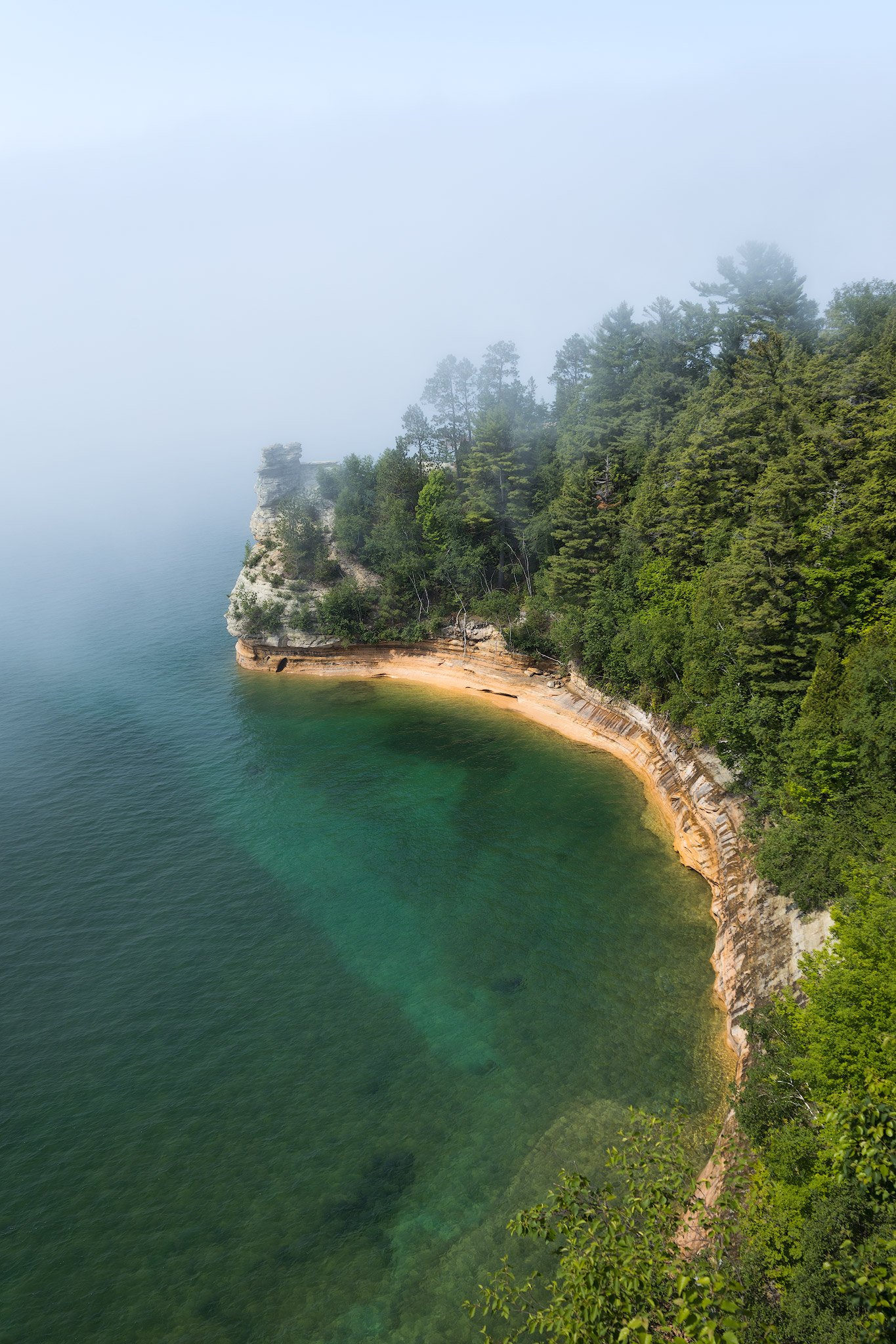
Backpacking Michigan’s Pictured Rocks National Lakeshore Trail
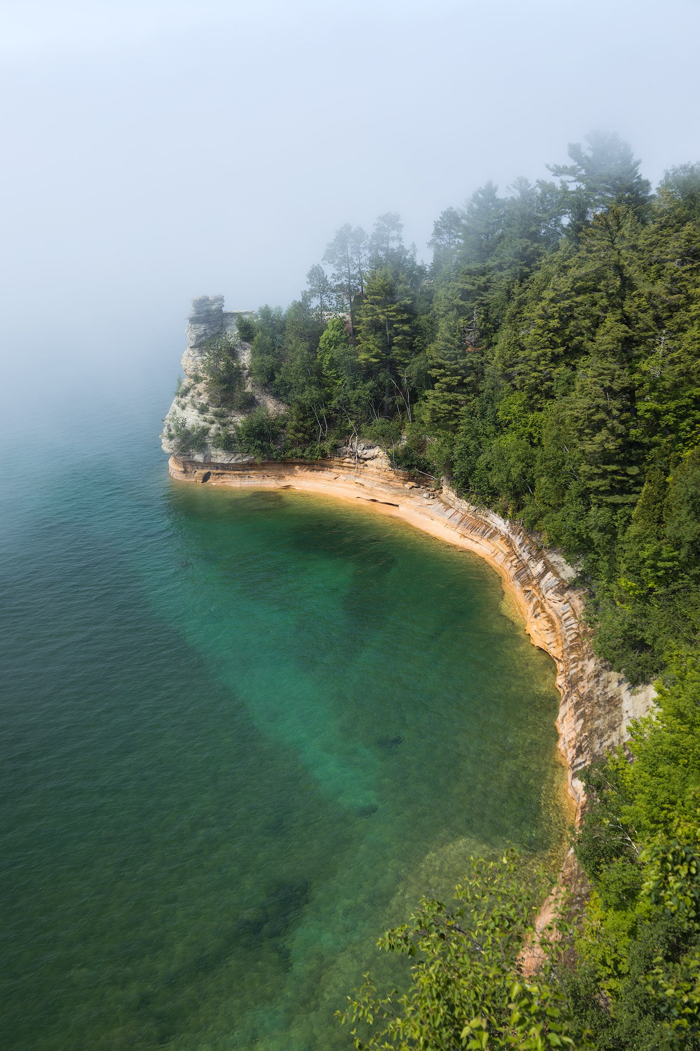
42 MILES OF PICTURESQUE BEAUTY ALONG LAKE SUPERIOR
Pictured Rocks National Lakeshore Trail is 42 miles long following sandy beaches and dramatic cliffs along Lake Superior in the Upper Peninsula of Michigan. It’s operated by the National Park Service and is only 1 of 4 designated National Lakeshores. The trail also shares the same path as the 4,800 mile long North Country Trail which is a continual footpath connecting Vermont to North Dakota.
Backpacking Pictured Rocks National Lakeshore Trail has been on my radar for quite some time. Every time I looked into it though it was always super hard to reserve campsites to make a logistical route due to permitting availability. This time I reserved the permit months in advance back in January for this trip at the end of June. Campsites cost $5 per person per night. At the same time I bought our Vehicle Entrance Pass which was $20. Also booked our shuttle from Altran Shuttle which was $35 per person. It dropped us off at the Grand Sable Visitors Center and we hiked back to our car at the Munising Falls Visitors Center. If you’re planning on hiking this trail always remember to Leave No Trace.
Navigation was pretty straight forward along this trail hugging Lake Superior. That said I still highly suggest bringing a paper map of the area and/or downloading the North Country Trail: Michigan UP Map on the FarOut app.
Most people do the whole trail in 3-5 days. Since my partner isn’t used to hiking big mile days we opted to do a longer trip with less daily mileage. We decided to spend a whole week on trail which is an average of only 6 miles per day. Another reason we wanted a longer trip was that we never get over to this area so we really wanted to take our time and enjoy it as much as possible. A big downside to an extended trip is carrying more food which I had in my pack. I appreciated every day we ate the weight away and my pack got lighter! On to the hike now. This is going to be a long read with lots of pictures but I hope you enjoy hearing about and seeing our adventure! I’ve found this to be the best method to really tell the story of the trail and show all of the photos taken along the way.
PICTURED ROCKS NATIONAL LAKESHORE TRAIL
DAY 1: GRAND SABLE VISITOR CENTER to AU SABLE EAST - 7.1 MILES
We took the Altran Shuttle from Munising Falls Visitor Center over to Grand Sable Visitor Center where we would hike 42 miles back to our car. The shuttle left at 7:45, or would’ve rather, but another couple was running 15 minutes late. While we waited we talked with another family hiking the trail in 6 days. Jeff, Denise and their son Hunter. It was Denise’s first backpacking trip. This was also the biggest trip for my partner, Julz. The shuttle is about an hour long which is funny to think about us taking 7 days to get back to the same spot! We got dropped off at the trailhead and began our hike at the same time the rain started.

Starting our hike at Grand Sable after getting dropped off by the shuttle.
The first mile or so is through thick overgrown grass & brush. Definitely do a tick check after going through there. Also highly suggest coating your clothes in permethrin before going hiking to help with the bugs. Not long into the hike we arrived at Grand Sable Lake.

One of the views along Grand Sable Lake.
There was quite a bit of a road walk here which I wasn’t really expecting. After a short while the trail went back into the woods and followed the lake some more. There were so many wildflowers and lush moss through this wetland area that just received a big storm. In fact we were in another storm now.

Julz in one of the swampy parts of Grand Sable Lake.
The rain came as a deluge. It was down-pouring for hours. Didn’t take many photos with constant cold rain. The trail was a bit flooded in a lot of sections. 5.8 miles into the hike we finally got to Log Slide Overlook. Unfortunately with the rain and the fog though you couldn’t really see the view. You could see Lake Superior on the beach below where people go down the massive dune, but we definitely weren’t doing that now either. We did see the shuttle family taking shelter from the rain under a structure with some old logging equipment. After a brief chat Julz & I decided to keep going to try to beat the next round of rain to set up camp. Just past the Log Slide was actually a fantastic overlook of the Grand Sable Dunes along Lake Superior. Though it was still foggy you could just barely see the massive shape of them with big waves rolling in below.

Foggy Grand Sable Dunes taken near the Log Slide Overlook.
From up on the dunes the trail suddenly & steeply drops down to Lake Superior where our campsite is at Au Sable East. We passed a creek where we stopped to filter water and grab more for camp. The campsite has water access right on Superior but with these waves it would be very difficult to get water without getting drenched and cold from the big lake. I mean we were already cold and wet from the rain. In fact we were freezing. It was low 50’s and the rain just soaked us. When we stopped hiking you really felt the cold. Once we got to camp I set up the tent right away and we got into dry clothes as soon as possible. We both might’ve been having early signs of hypothermia to be honest. We got changed quickly and made some hot cocoa and hot dehydrated meals to warm us up which definitely helped. Thankfully there was a brief reprieve in the rain as well.
After awhile the shuttle family rolled into camp and they somehow got a fire going with the one piece of dry wood. We all gathered around the fire where we hung a line over to try to dry out our soaking wet clothes. Another person was camping here too, Debbie, who was out solo hiking on a 5 day trip. We all had the same cold shock hiking in this rain today. It was tough even though it was only a short 7.1 mile day. We’re all looking forward to the supposedly sunny day tomorrow and are actually all staying at the same campsite tomorrow too at Sevenmile Beach.
After warming our bones by the fire for awhile we put it out and went to bed early around 9 pm. I didn’t bother with any sunset photography with how cold and gloomy it was. The rain started again when we got in the tent. I fell asleep to the pitter patter of raindrops and the crashing sounds of waves.

Small scene on Lake Superior at our campsite at Au Sable East.
DAY 2: AU SABLE EAST to SEVENMILE BEACH - 7.3 miles
Slept in until around 8:30. Peaked out the tent around sunrise earlier and it was still very gray and cloudy out so didn’t bother getting up to take pictures. We took our time getting ready while making coffee & oatmeal to warm up. It’s supposed to be around 50 degrees again all day but at least there’s no rain forecasted. Before leaving camp I took down someone’s paracord clothesline they left behind and put it in my bag. Ended up using it as a clothesline myself at our campsites the rest of the trip. We’ve all been finding a bunch of trash and gear left behind by others which is unfortunate. As we were leaving though there was a tiny baby bunny right on the trail which brightened our day right away.

Little bunny right on the trail leaving camp.
After seeing the little bunny and getting back on the trail along Lake Superior we were in much higher spirits than yesterday. The big lake was starting to get a little more calm as the wind was dying down and the sun was coming out. As I was taking some pictures I even caught Julz just basking in the sunlight.
In a short .4 miles we got to the Au Sable Lighthouse. It was a very cool spot. There were lots of wildflowers around the sand here I used to frame up the lighthouse. They offer tours where you can go inside to check it out but unfortunately it’s closed on Mondays & Tuesdays so we won’t be able to get in there. Still we could’ve spent lots of time just hanging out here.

Au Sable Lighthouse
We were planning on getting water from the fountain here but it was wrapped up with a garbage bag & a sign that read “no potable water.” Keep that in mind if visiting anytime soon and relying on that. Can still filter water from the lake though. We had enough water to get us to the next water source anyway.
After the lighthouse the trail was a big wide easy going path with lots of other day hikers out now. There was an interesting sign with shipwreck information of all the ships that have sunk nearby on the shallow sandstone ledges. With the bigger waves coming in we didn’t go investigate to see if we could see any remnants on shore. Can see why they needed a lighthouse here though!

The beach where the shipwreck signage was.
We arrived at the Hurricane River Campground which was a super busy car camping area. There was people everywhere. We took advantage of the bathrooms and garbage cans to unload our trash from yesterday & today. Before leaving we went down to the mouth of the Hurricane River to get some water. I felt the eyes of a crowd of people watching as I filtered water from the stream wondering what I was up to. Finally we left the mass of people behind us as we continued on our way. This whole stretch of trail was along a beautiful sandy beach for miles and miles.

Steps down to the beach along Twelvemile Campground.
Once we got to Twelvemile Campground we ran into our trail family eating lunch at a picnic table where we joined them for a break. After awhile we were on our own again and hit the trail. It was so nice right along the lake. There was a ton of erosion happening though where the trail goes. Jeff said there was much more erosion compared to the last time he was here only a year ago. Lake Superior did get hit with a ton of major storms this past winter that might’ve wreaked havoc on this fragile shoreline.

Erosion eating away at the sand dune the trail follows along on Twelvemile Beach.
Not much of note until we got to our campsite at Sevenmile Beach. Actually the group campsite came up first. There we ran into Debbie again who was coming down the trail from the latrine at the group campsite. Turns out that’s the only bathroom here and our campsite is .2 miles away. Pretty far to go to the bathroom! We crossed Sevenmile Creek and got set up at our campsite while drying our gear in the patches of sunlight. Our site was nice and private but wow site number 4 & 5 are very nice right on the creek. I scouted the beach for sunset locations too. Due to major erosion the main way down to the beach is a scramble but there was another way down closer to the creek. It was nice down there right on the mouth of Sevenmile Creek flowing into Lake Superior. Found exactly where I was going to shoot for both sunrise and sunset later on. On my way back to camp I saw a few Lady Slipper Orchids that were just glowing in the direct sunlight.

Ladyslipper in the sunlight.
Once we got a fire going we were joined by others from the campground. We shared stories and passed the time until sunset when a few of us went down to the beach to check it out. Julz went to the creek to soak her foot in the cold water to help with swelling she’s been experiencing. Unfortunately the sunset wasn’t spectacular and it happened prematurely due to a low hanging wildfire cloud bank and haze on the horizon from the Canadian wildfires. Still I got a photo that I was envisioning when scouting earlier.

Hazy wildfire smoke sunset reflecting in the water of Sevenmile Creek & Lake Superior.
Some of us stayed up a little longer to burn down the fire more before putting it out. The bear box was super full today with so many people here but we made it work. It was a late bedtime at around 11:30. My sunrise alarm is set to go off in under 6 hours…
DAY 3: SEVENMMILE BEACH to BEAVER CREEK - 6 miles
The alarm came soon. I got up at 5:20 and was actually pretty surprised that I was the only one awake and witnessing the sunrise down here on the beach at the mouth of Sevenmile Creek. The sunrise was better than the sunset as now the sun was rising perfectly along the shores of Lake Superior. I took it in for a bit before retreating back to the tent to rest a little bit longer.

Sunrise at the mouth of Sevenmile Creek flowing into Lake Superior.
Back in the tent now we slept in until after 9 and ended up leaving around the same time as yesterday at 11. We were the last ones out of camp, but that’s ok we only have 6 miles to hike today. After today we won’t be seeing the family or Debbie again as we all have different campsites. The other people with us last night are heading the other way as well. The trail has been easy going on smooth, well worn tread alongside the big lake which was very calm and peaceful today. There were quite a few parts where erosion was creeping into the trail. There was also a lot of downed trees by the lake - none on the trail though as they’ve all been cleared by maintenance crews.

Julz on the sandy pine studded trail next to Lake Superior.
There really wasn’t much of note on this section of trail. At least not for around 3 miles when we came across a random old car in the middle of the woods that stood out like a sore thumb.

Old abandoned car in the woods between Sevenmile Beach and Beaver Creek.
From here we debated on taking a slight detour over to the inland lakes of Trapper Lake and Beaver Lake. Julz didn’t want to put any extra steps on her foot if she didn’t have to though so we stuck with the main path. Right after the trail juncture to the inland lakes was a little sandy path down to Lake Superior where we took a break on a big piece of driftwood. Rested our feet, ate some snacks and filtered more water from the big lake for the last stretch to the campsite. From the sandy beach we could see people further down on the nearest site at Pine Bluff.

Taking a break on a sandy beach.
We got into the Beaver Creek Campsite around 3 PM. We were the first ones there but when we checked the bear box someone had left all of their garbage including whole oranges and an empty fuel canister. Our site also had a make-shift fire ring someone made even though you’re only supposed to have fires at the communal fire pit by the bear box. This wasn’t the first make-shift fire ring I’ve seen at campsites either unfortunately.
Once camp was all set up we went down to the creek to rinse our clothes and soak our feet. There was a ton of downed trees over the creek here. Looked more like Lake Superior pushed them all in there during big storms rather than from beaver activity considering it’s called Beaver Creek. It was still super nice to wade in the waters of the creek. It was much warmer than the freezing Lake Superior! I scouted out a spot to shoot sunset but with more rain coming I didn’t plan on going out later for it. Planning on skipping sunrise too with what the forecast was looking like. The shape of the creek here was a lovely S-Curve as it flowed into Lake Superior.

Beaver Creek flowing into Lake Superior.
Back at camp we made dinner and got situated for an early night. While we were down at the creek Julz discovered she had several little blisters on her toes so we spent some time taking care of those and wrapping them in leukotape & moleskin to help prevent further friction. We thought about having a fire but then the rain came. It was just a light rain but it held up for a little bit. Still it was warmer tonight than the last few nights. It was a nice 68 degrees at 9 PM. The campground is much more quiet than the others we’ve stayed at so far. It’s up on a sand dune away from the lake and the river so there was no sound of moving water for the first time. We went to bed planning on actually getting up early so that we can get to the much anticipated Chapel Beach area as soon as we can to spend the rest of the day there.
DAY 4: BEAVER CREEK to CHAPEL BEACH - 5.6 miles
Around 7 AM we woke up to heavy rain. With just barely enough cell service I was able to pull up the weather forecast. Looks like rain until 8 or 9 and then chances of rain throughout the rest of the day. We’ll need to get to camp early as it also looks like there will be heavy rain again from 6 to midnight tonight. You never really know though as the weather can change drastically and quickly on Lake Superior.
Even though we were up earlier we took our time getting ready. Think the rain just made us lazy while we had our little breakfast in the tent. Once we were back on trail we immediately came to a really neat wooden bridge made of old logs. Beaver Creek below was shallow and crystal clear to the sandy bottom.

Julz on the wooden bridge over Beaver Creek.
As we started to get closer to the Coves Campground the terrain started to get a bit more elevation compared to the flat beaches. All of a sudden a huge wall of sandstone jutted out in the middle of the forest.

Julz next to a giant sandstone formation in the middle of the woods.
The signage of the Coves Campground was a bit confusing. There was a group campground, the individual campground and then another group campground 1.5 miles further. I guess there’s two group sites at Coves and they’re spread out super far? We checked the bear box at the first group site and found an empty Red Bull can. Who goes hiking with a tall boy Red Bull and then just leaves it? Anyways the shoreline was getting more & more dramatic, much like me when I find litter. There were a bunch of little coves with peaceful turquoise waters all around. Exploring this area in a kayak would probably be the best experience, but I like to keep my feet on dry land mostly.
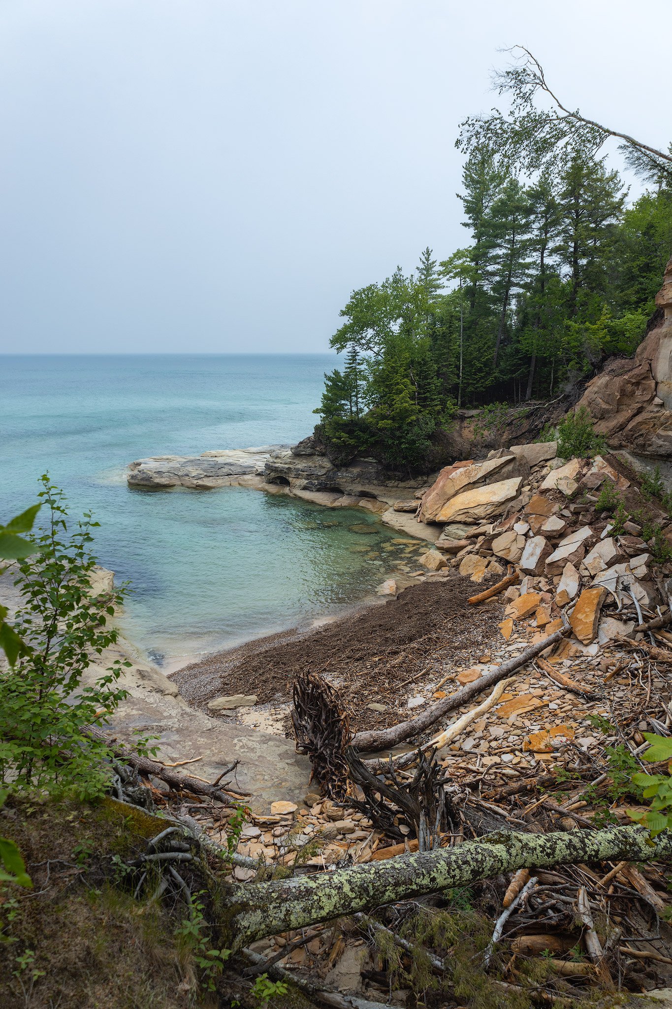
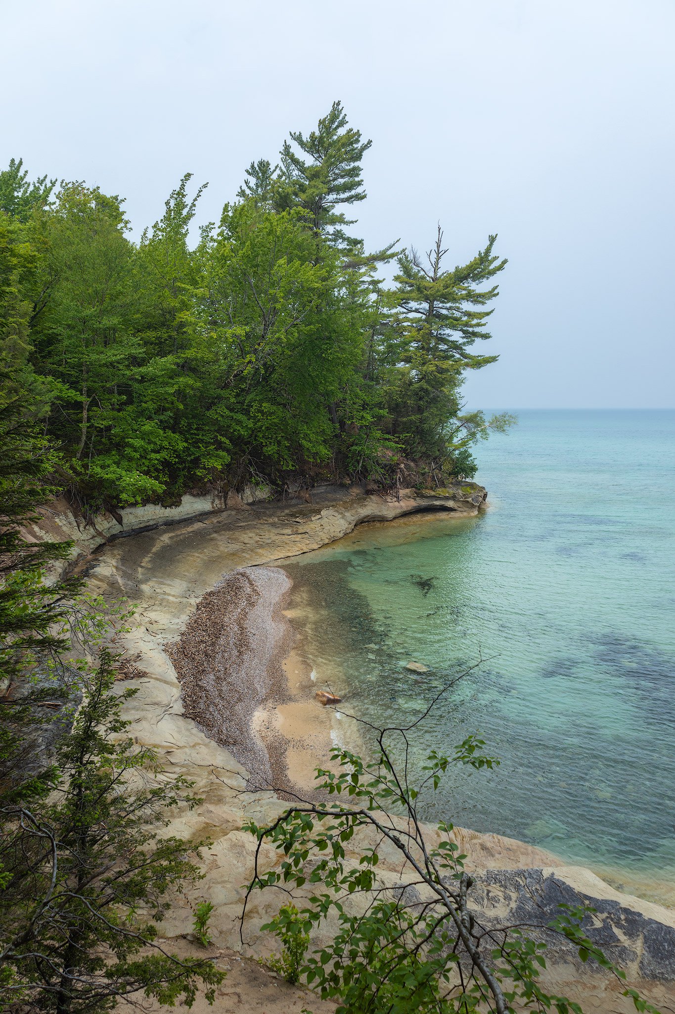
The trail began to climb up above the Lake more around here. At one of the many overlooks I was drawn to one little scene directly below us from atop a big cliff. The waters below were a brilliant turquoise color with shallow rocks laden with worn kettle holes throughout the rock. Seagulls were soaring all around us and I tried my best to time this shot with a seagull flying into frame.

A seagull soars over Lake Superior as seen from a cliffside overlook.
Less than a mile after the last Coves Campground is the overlook for Spray Falls. I was looking forward to this one for awhile now after seeing pictures of this photogenic chute of water cascading into Lake Superior. Unfortunately the lighting wasn’t great when we were there and it was a bit hazy from the Canadian Wildfires. I also didn’t have a Polarizing Filter with me, but it was still cool nonetheless. Wish my lens could reach a little further as well. My lightweight backpacking lens only goes to 105mm. A 70-200 would be perfect here if you’re thinking about hiking one in.
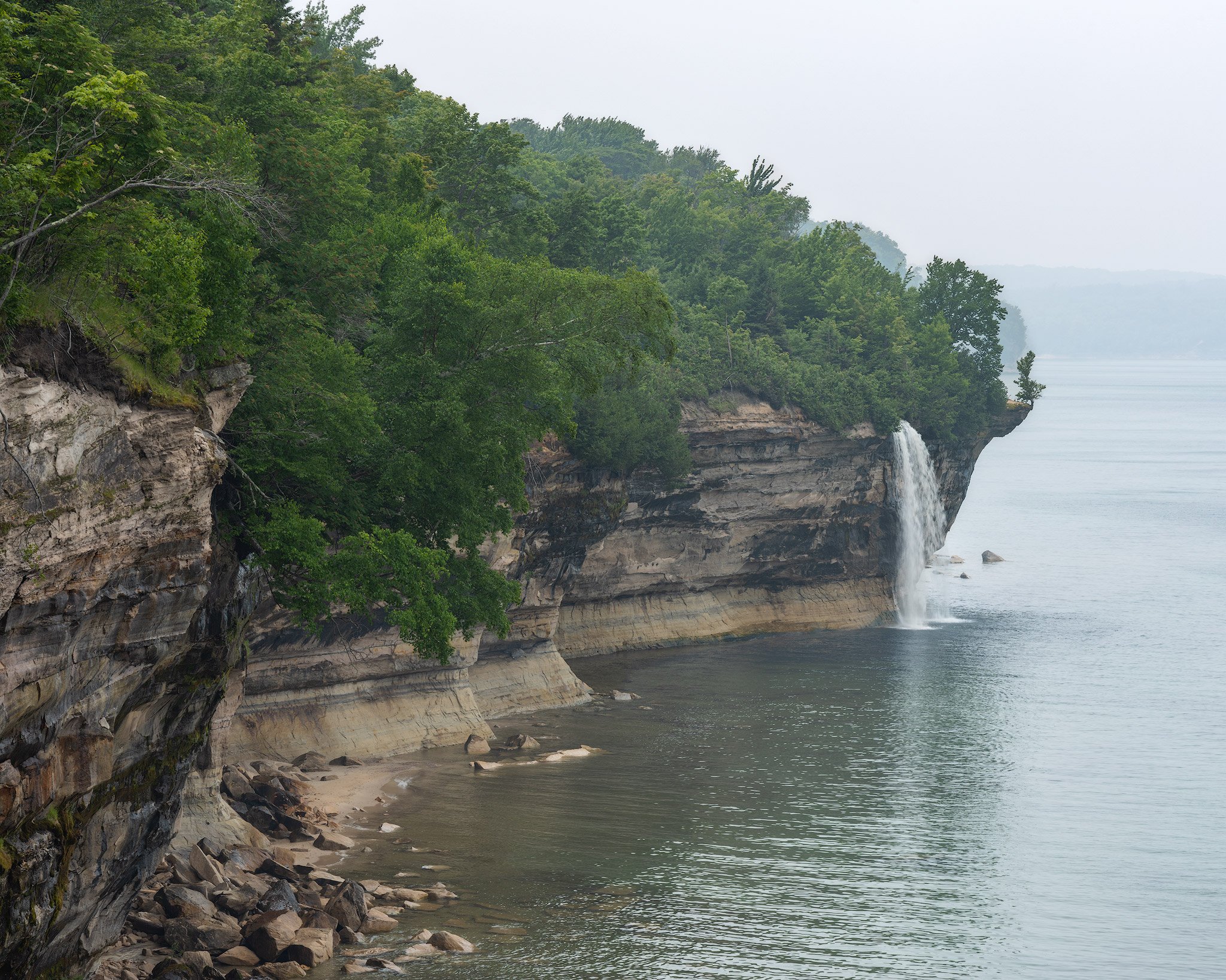
Spray Falls overlook.
Even better than the overlook of Spray Falls was the trail along Spray Creek that lead right to the top of the falls where it plummets 70 feet over the cliff into Lake Superior. It’s pretty incredible and the perfect place to filter water. Just be very careful up there! We sat here for a bit watching the water disappear in front of us. A passing pontoon boat pulled up to the falls and waved at us eagerly as we were leaving.

At the top of Spray Falls where it plummets 70 feet off of the cliff into Lake Superior.
The trail seemed to change ecosystems frequently through here and felt otherworldly at times. There was one sandstone cliff shelf in particular that was a big wide open ledge with a sandy beach, but it was a good 50 feet up above the water. Julz called this spot the moon. There was also a lot of erosion along the trail. One spot was especially bad where you could see the trail had fallen in to the lake below.

The trail on this cliff has fallen into the lake. Watch your step!
Chapel Rock stood prominently in front of us as we neared Chapel Beach. Such a unique and longstanding rock formation with history of it being used as a navigational point for centuries to those on Lake Superior. As interesting as the history is the trees standing firm on top of it with its roots spreading and reaching out to the mainland. This used to be an arch at one point, but it has since collapsed. The roots that were once on top of the arch still hang in there. Boats were passing by and people were swimming in the waters all around. This is the busiest place we’ve seen in Pictured Rocks so far and for good reason. I’m excited to explore this area more. First we have to set up camp.

Chapel Rock from the trail above with a pontoon boat going by on Lake Superior.
With camp set up at the campground we went back down to the beach to scout out my sunset & sunrise locations. Chapel Rock looked interesting from this side but my favorite feature was actually Chapel Beach Falls. This was a lovely little waterfall that had a smooth cascade right into Lake Superior with Chapel Rock in the background. Chapel Creek also flowed right past our campsite a little ways upstream. I decided I’d come back to the falls for sunset and sunrise as well. For sunset I’m hoping to get a Golden Hour glow on the falls with Chapel Rock in the background. Sunrise lines up right along the shore behind Chapel Rock if the weather cooperates.

Chapel Rock from Chapel Beach.
Speaking of weather we were supposed to get dumped on with rain soon according to the weather forecast I was able to pull this morning. We decided to go back to the campsite to eat dinner. By the time we were done eating was about when the rain was supposed to hit but the sky above looked bluebird now. Back down to the beach we went and sure enough it was a beautiful sunny day now but to the right down the shore was a dark storm cloud that must’ve somehow went right around us.
We soaked up the much needed sun for awhile until I noticed the nice golden glow starting to light up Chapel Rock. I grabbed my camera gear and went back down to the waterfall.

Golden Hour glow at the Chapel Beach Falls & Chapel Rock.
I joined Julz back at our chill spot where we watched the sun prematurely set about a half hour before it was supposed to as it disappeared behind the hazy Canadian wildfire cloud bank over the lake once again. It was setting right next to a protruding point on the other side of the beach.

Hazy wildfire smoke sunset at Chapel Beach.
Once the sun was hidden it got noticeably colder immediately. We retreated back to our tent for an early bedtime. I love how backpacking seems to reset my sleep schedule to actual normal times. I also much appreciated being next to a creek again for that soothing sound of rushing water helping me fall asleep. Today was probably the best day of the trip so far. Inside the tent Julz showed me a picture she took of me earlier at Chapel Beach Falls where I look like I’m in my happy place. We’re both looking forward to what tomorrow has in store for us!

In my happy place on trail.
DAY 5: CHAPEL BEACH to MOSQUITO RIVER - 4.4 miles
I woke up for sunrise at 5:20 and went back down to the waterfall. Unfortunately it was quite foggy and hazy and there was a large cloud bank where the sun was going to rise. I sat there for awhile just taking it in and hoping the sun would make an appearance or some colors would light up. Though it never happened it was still nice being the only one out on the beach at this time.
Instead of falling back asleep after that we actually did get up early and started packing up. The stretch ahead is also very beautiful so there’s much to see and it would be nice to chill at the next campsite for awhile. By the time we got going the clouds cleared and it was a beautiful sunny day! Still the haze was ever present on the horizon across the lake. There was however nice early morning light on the cliffs to the left of the beach.

Early morning light on at Chapel Beach.
It wasn’t long until we came to Chapel Cove. It’s a long narrow cove right behind the point we just took pictures of. It’s just wide enough for the tour ferries to go into and back out of. We kept seeing them go into it from Chapel Beach but couldn’t tell what they doing from there. Up here though it’s a nice view into turquoise waters with lots of shapes and definitions in the rocks from moving water over time.

Chapel Cove. Spot Julz on the cliff to get a sense of scale for how big this cove is.
As we climbed higher up above the lake on massive cliffs we occasionally got a fantastic view through an opening in the trees. This photo below was a good one with that nice curve in the rock and glowing shelf below it in the water.

Beautiful rock formations above and below the water.
Now we were getting to a place I’ve been looking forward to and hyping up this whole trip: Battleship Rock & Grand Portal Point. I guess I jinxed it because as soon as we turned a corner to the overlook at Battleship Rock a massive wall of fog drifted in. Not only we were completely socked in with the views, but also the temperature drop was sudden. All we could do was laugh it off as we stood at Battleship Rock and couldn’t see ten feet in front of us. This just means we’ll have to come back another time!

Me fogged in at Battleship Rock.
By the time we got to Grand Portal Point we were really hoping the fog would blow over or at least clear up a little bit. Not at all though. It kind of made for an interesting photo though with the rocky overlook seemingly disappearing into the abyss. Hard to tell from the photo here but we’re a couple hundred vertical feet above Lake Superior!

On top of Grand Portal Point with fog all around.
As much of a bummer as it was for the fog to completely hide our major views, it still created a unique atmosphere in the woods the trail winded though. I love a nice foggy woodland shot and was happy to get one here. The ferns were huge, adding a nice layer to the underbrush and the fog created some separation of the prominent trees and the background.

Foggy woodland scene.
Again the ecosystem seemed to change as it does often throughout this trail. Immediately after that foggy woodland section was a very big patch of blowdown. There must be a perfect wind tunnel through here that created this carnage as we called it. The fog added to the despair even more.

Major blowdown section on the trail with hundreds of down trees.
As if on cue, right when we got to our site at Mosquito Campground the fog cleared up. Go figure. But at least it made way for a beautiful sunny day! Which then turned into a beach day for us. Now this is probably our favorite place on the trail so far! It’s such a unique beach area made mostly of sandstone shelves with a lots of interesting formations. The usually cold Lake Superior water seemed more bearable near the shallow sandstone areas, especially after hiking over 30 miles!

Fog lifting along the shores of Mosquito Beach.
Mosquito Creek flows right through the campground and empties into Lake Superior via a very shallow cascade of many spaced out ledges. We waded in the waters of the slightly warmer creek. Hours were spent exploring all over this cool shoreline and could easily spend way more. Julz ended up getting pretty sunburned here though as we were enjoying it a little too much!
Sandstone shelves along Mosquito Beach.
We retreated to the shade of our campsite to make dinner. While we were cooking and waiting for meals to heat up a NPS Park Ranger came by the campground to check for everyone’s backcountry permits. I’ve heard of them doing this before and makes sense to do it now and here at this very busy area on a Friday of Fourth of July weekend! As we were chatting while he was checking the permit we brought up the fog coming in right as we got to the best views in the park and even he said the fog was wild how fast and thick it came in!
After we ate it was starting to get into Golden Hour light so I went out to photograph all of the spots I had scouted out while chilling on the beach all day. The main photo I went for was from inside of a tiny little sea cave. This “cave” is only about 4 feet tall and maybe 10 feet deep. I was crouched down at the very back of it to get this photo of the sun lighting up the inside and reflecting in the still water inside the cave.

Sunset Golden Hour light inside of a tiny little sea cave along Mosquito Beach.
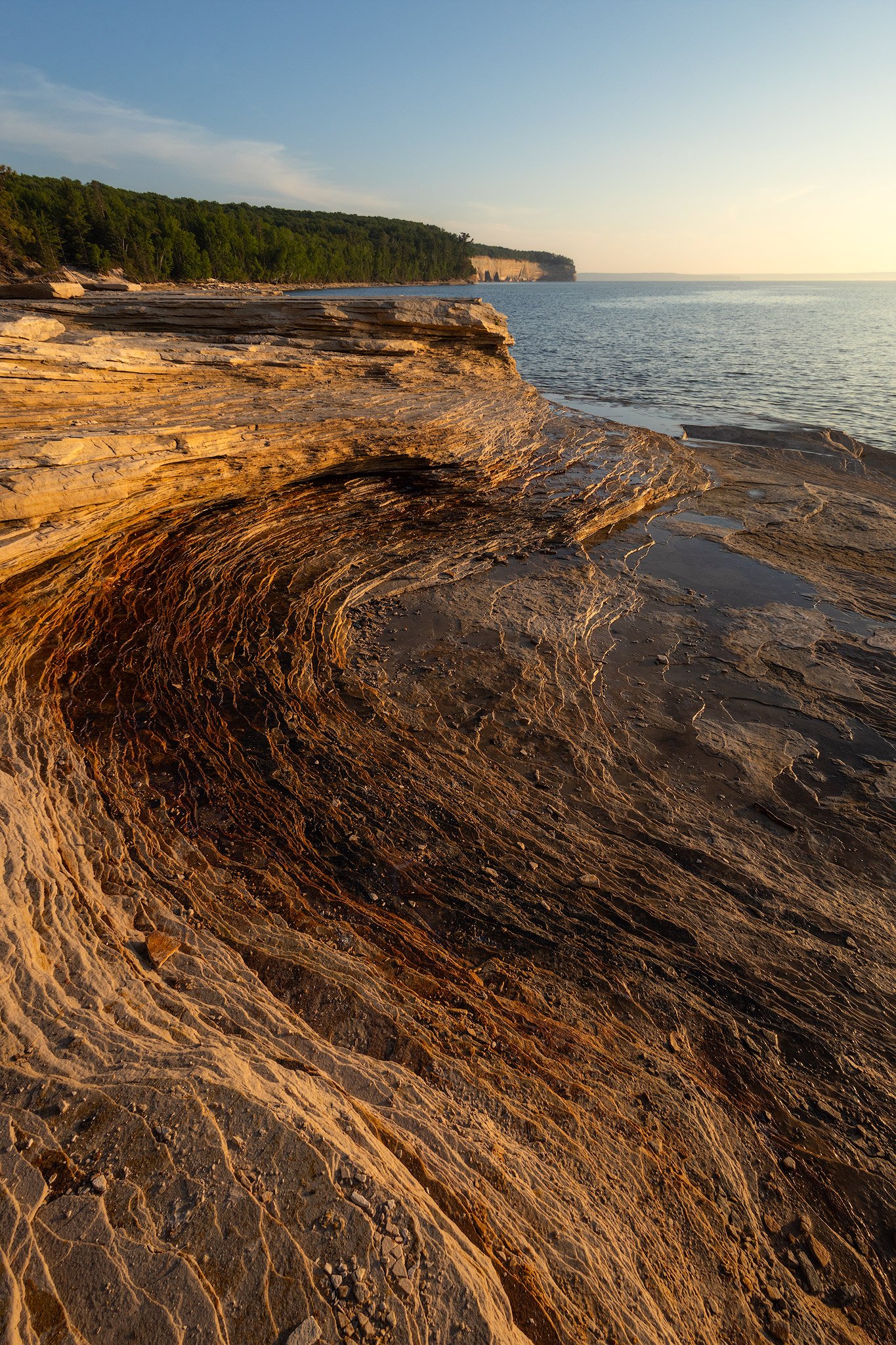
Outside of the cave I turned my attention to the ground. Since there wasn’t any clouds or color in the sky I was focusing on where the light was shining. I found this little abstract scene where lines of sandstone layers were being side-lit by the setting sun. Believe it or not this photo is actually one of my favorites from the whole trip.

Layers of sandstone side-lit by the setting sun.
The campground was packed for the night. So much so there was often a bit of a line to use the latrine. The bear box was also super full with everyone’s food bags and some big garbage bags that were taking up a lot of room. I liked site #1 we were in as it was the closest site to Lake Superior to hear the waves coming in.
DAY 6: MOSQUITO to CLIFFS, 6.9 miles
Once again there wasn’t much of a sunrise. With the ever present wall of haze on Lake Superior from the Canadian wildfires and low clouds on the horizon there really hasn’t been many opportunities to work with pretty photographic light on this trip. That’s alright anyway because my camera batteries were about dead. I brought three with me and two are pretty much drained. The third one I grabbed right before I left home and didn’t bother to charge it thinking it was full. That was a mistake as it was completely empty and I was just carrying dead weight this whole time. I usually always double check my electronics before leaving but lesson learned! I’m conserving batteries for the rest of the hike knowing I only have a few photos left in the battery.

Sunrise at Mosquito Beach.
After shooting sunrise we said goodbye to Mosquito Beach which was a definite highlight for both of us. There were several nice cliffside overlooks today so at least we got to see some grand vistas. Another thing we didn’t get to see from the trail is Bridalveil Falls. It’s only visible from the water but it’s a lovely photogenic cascading waterfall slowly running down a slanted cliff into Lake Superior. Would definitely take a Pictured Rocks Cruise or Pictured Rocks Kayaking trip to see that and the other features we’ve missed along the way. Would also be nice just for a different perspective of everything.

One of several cliffside overlooks we saw between Mosquito Beach and Miners Beach.
The cliffs along Lake Superior were amazing, but then we came across another wall of rock in the middle of the woods that came out of nowhere. This one was huge. Much taller than the other one we saw on trail a few days ago. I wanted to stop and take more detailed photos of this structure but with my camera batteries dying we continued on.

Julz standing next to a giant wall of rock in the middle of the woods.
It wasn’t long until we arrived at Miners Beach. This is another long & stunning stretch of sandy beach. We hiked to the end of the beach where Miners River flows into the lake. It’s a really cool spot and very, very busy this holiday weekend. There’s a huge parking lot right next to the beach so it’s an easy access point. We took a two hour long break to have ourselves another little beach day and explore this unique beach. Neither of us took many photos as we were both just enjoying ourselves. Plus there were too many people to get a good shot without a bunch of randoms in it. You’ll just have to go see and experience it for yourself!

The end of Miners Beach. Miners Creek flows into Lake Superior to the left of this photo.
After awhile we had to cut ourselves off from the beach day as it was getting later and we were both getting a lot of sun. We were drinking a ton of water and powdered drink mixes at least. There is no water source at our campsite tonight at Cliffs so we decided to hydrate as much as we could now. When we were back on trail and came to Miners River there was a sign warning about no water past this point. I filled up my 1 liter bottle, Julz’s .75L bottle, and my 3L water bladder which went inside of my backpack. I was definitely feeling that extra 6.5 pounds of water inside the bladder. Turns out there was an actual water fountain at the Miners Castle Visitors Center not far ahead. That potable water did not taste great though. It was very irony and tasted like what a porta potty smells like. The water fountain was connected to the bathroom there I guess... Julz refused to drink anymore of that water after I brought up what that taste reminded me of… We definitely preferred all of the water we’ve been filtering from rivers and Lake Superior this trip.
Miners Castle was also super crowded. People were crowding the observation deck with the best view of it from the top and the side along the shore. This view also didn’t have a ton of steps like the lower platform does. I bet it was crowded now as the fog had moved in again but was just starting to lift, revealing the hidden beauty. I got some amazing photos of the fog clearing around the castle. Unfortunately my last camera battery died while I was taking a horizontal version of this shot which I prefered even more. Still super happy with this photo of Miners Castle though! This was the last photo taken on my camera. There wasn’t much left to the hike at least, and phone cameras are pretty capable these days.
Fog starting to lift and drift around Miners Castle.
The last stretch to our campsite at Cliffs Campground wasn’t very notable besides lots of mud. Well I guess a ruffed grouse also charged us right when we walked into our site. Her baby chicks were chirping on the other side of the trail as we inadvertently got in between them. It later sounded like they reconnected again. I did notice a bunch of mushrooms in this area which was pretty neat.
We both agreed this was easily our least favorite campground we stayed at though. There’s no view as it’s just in the woods. To be fair there might actually be a little bit of a glimpse of Lake Superior right before you turn off the trail into camp, but we were completely fogged in when we got there and when we left. The campground itself was wide open. Even though there were only 4 sites there wasn’t any privacy. Was surprised they allow campfires here too considering there’s no water source nearby. Really trusting people to properly extinguishing their fires with little water available.
At the moment it was just us and one other couple. A group of 3 came into camp pretty late around 7:30 and were kinda loud throughout the night. I was super tired and had trouble falling asleep with them talking. Still I fell asleep around 10. Found out in the morning from Julz that she didn’t fall asleep until midnight because they were talking loudly until then around the fire. I don’t think people realize how much their sound travels. That’s one reason I really like staying next to a river or a beach to have the sound of water drown out other noises. Anyways this is our last night. We’re both looking forward to sleeping in an actual bed tomorrow.

So many interesting mushrooms along the trail.
DAY 7: CLIFFS to MUNISING VISITORS CENTER, 5.1 miles
Started this trip in the rain and looks like we’ll be ending it in the rain as well. However it wasn’t a relentless cold rain like day 1 and it let up pretty early on. If there were any views to be had from the cliffs up here there were none to be seen with fog everywhere once again.

Julz at an opening near the Cliffs Campground with fog obscuring the view.
On the trail there were so many creeks along the way that turned into waterfalls cascading down the cliffs and into Lake Superior. If only you could actually see them from the trail we were on. Could only see it go over and hear the sound of it. There was one bigger waterfall but it was mostly hidden by trees. Looking forward to capping off this trip by taking the short walk to Munising Falls once we get back to the car in a few more miles.
Speaking of Munising Falls we came to a fork in the trail with a sign pointing that way in 2.7 miles. Opted to skip the Sand Point section the other direction. It did look like a cool trail from the fork going down wooden steps along a moss covered cliff wall. Sort of reminded me of the Wisconsin Dells area. We’ll have to come check it out another time. Especially since we missed seeing Grand Portal Point when it was foggy.
When we got to the Munising Falls Visitors Center we were shocked to find hundreds of people and the parking lot completely full with more cars lining the road. When we parked here a week ago we were one of the only cars there! It is Fourth of July weekend though so everyone is out enjoying the area.
After finally taking off our backpacks we took the short walk over to see the falls. There’s 2 trails there, one to go to the Upper Falls and one for the Lower Falls. Once we saw all the stairs we skipped that route even though people said it wasn’t very far. We just hiked 42 miles! At the base of the waterfall the viewing platform was full of people so we had to wait to take our picture together there. Such a stark difference from being in the woods away from people for such a long time!

Celebrating ending the hike with a selfie at Miners Falls.
That’s it for this trip. Thanks for reading and hope this inspires you to get out and experience Pictured Rocks for yourself! If you’re unable to hike the full trail there’s many smaller day hikes or overnighters one could hike. The tour boats from Munising are also very accessible ways to see the shoreline from the water.
Feel free to check out my other blogs for more Trip Reports like this! If you enjoy this free content please consider making a CONTRIBUTION, purchasing PRINTS (many of these photos are available), and follow along on Social Media at Instagram, Facebook, & YouTube. Your support is greatly appreciated to help cover travel costs, permits, gear acquisitions, and time commitments needed to get outside and share these adventures with you all. Thanks!
Trip Report from backpacking the 42 mile long Pictured Rocks National Lakeshore Trail. It follows sandy beaches and dramatic cliffs along Lake Superior in the Upper Peninsula of Michigan.